| North America United States of America | Duration : 5 Days / Driving Time : 16 hours Total Distance : 1464 km |
The route described here is a fantastic 4 day trip which isn't a complete circuit. Indeed, driving will be done from Phoenix to Las Vegas, meaning an initial flight is required to get to Phoenix. The trip can easily be extended for visitors who plan to see more detail of the different places. However, the trip described below will let you take a glance at :
- Grand Canyon National Park
- Sedona
- Monument Valley National Park
- Antelope Canyon and Lake Powell
- East Grand Canyon National Park
- Bryce Canyon National Park
- Zion National Partk
Day #1: From Phoenix to Grand Canyon via Sedona
Main milestones :
Phoenix to Sedona : 1 hour and 55 minutes
Sedona to Grand Canyon : 2 hours
This first day of route is probably amongst the longest since it is the far stretch out of Phoenix right over to Grand Canyon National Park. Fortunately, there is a break half way to the destination, through the magnificent town of Sedona, roughly 120 miles from Phoenix. On interstate I-17, 90 minutes after leaving Phoenix, take exit 298 in direction of Sedona and Oak Creek.
The pictures you will see below are taken at Bell Rock located between Old Creek Village and Sedona and where you get a wide open view on the east side of the Red Rock State Park.
After crossing Sedona, there is a beautiful but windy and narrow road that goes through Slide Rock State Park and rejoins Interstate I-17 just south of Flagstaff. Route US-180 will take you directly to Grand Canyon Village, which is where most visitors park their cars and sleep. The aim for the remaining hours of the day is to head west to have the view on the sunset on Grand Canyon. Park your car and jump into the free bus (bus stop HERE) to be dropped off at the nicest viewpoints overlooking the deep canyon. Pictures below were taken from Hopi and Mohave point, which, in my opinion, are the ones offering the nicest view on the Grand Canyon at sunset (see tourist map HERE). As it is high altitude, make sure you have hot clothes on as the sunset is linked to a sudden drop of temperatures and you regularly get frost building up over night :
You have multiple options for accomodation but as in all USA National Parks, the lodging inside or at the entrance of the National Park is always more expensive. Here are a few ideas for affordable nights (with either proximity to Grand Canyon on more comfortable but more distant accomodation) :
- Grand Canyon Village - Bright Angel Lodge & Cabins - Starting 90$
- Tusayan - Best Western - Around 220$ per night
Day #2: From Grand Canyon National Park to Monument Valley
Main milestones :
Grand Canyon Village (Arizona) to Monument Valley (Utah) : 2 hours and 50 minutes
The next morning, you can either take one of the trailheads directly from Grand Canyon village but expect a steep and long walk down to the canyon. With small children, it is best to take your car and head east to see the other amazing view points on the Grand Canyon. Be very careful though as many places aren't secured by barriers and a fall in those areas would be fatal. The pictures below were taken from Grand Canyon Village at the start of Bright Angel Trailhead :
Then, after a short drive east, you will have the view on Yavapai and Yaki Point where the cliffs get much higher, giving a better view on the real depth of the Grand Canyon.
Should you want an even more spectacular view, you can get a short helicopter tour round the canyon, you can head to Maverick Helicopters at the airport of Tusayan, to get view of the Grand Canyon from the sky :
It is then time to head in direction of Monument Valley. This 3 hour drive on very smooth roads will lead to beautiful changes in scenery. Trees will gradually vanish leaving wide open areas of dust and red rock.
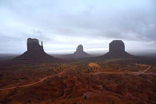
North of Kayenta, on route 163, you will come across several beautiful places to stop and take scenic pictures until you reach the entrance of Monument Valley, located in the indian Navajo on the Colorado plateau. I was unlucky with weather the day of my visit and didn't manage to get the beautiful sunset and sunrise on the scenery but here are pictures of the most famous parts of Monument Valley, with the East and West Mitten Buttes with Merick Butte in the background.
Note that to drive in Monument Valley, you will require a high clearance vehicle. Also, the track in the National Park can be complicated without a 4 wheel drive car when it is raining
There are multiple options for accommodation but I advise you to book early.
- The best of all but also most expensive is The View hotel but in high season, prices can range from 230 up to 280 $ per night. The main advantage of staying there is that you are located directly at the entrance of Monument Valley National Park
- Slightly further away, crossing route 163, you have Goulding's Lodge, and slightly cheaper Goulding's Apartments which are more affordable and still in close reach of the National Partk
Day # 3: From Monument Valley to Page (Arizona)
Main milestones :
Monument Valley to Page : 2 hours
Page to Horseshoe Bend : 10 minutes
Antelope Canyon is beautiful but the visit it most interesting at noon, when the sunshine rays can reach the ground inside the canyon. Should you not book your visit at noon, you may be disappointed as you won't have the beautiful colours and sunshine inside the canyon.
Booking must be done with a lot of anticipation due to popularity of this event. There are plenty of Navajo guides and companies that will take you around the slot canyon. I picked this one but I guess most others are convenient too.
Antelope Canyon is devided in 2 parts, seperated by route 98, 10 minutes east of Page. The Upper Antelope Canyon, which is the nicest is located south of the road (10 minutes drive on a dirt track and in the river bed) whereas the Lower Antelope Canyon is on the North Side of the road and turns into a wet canyon when the canyon meets the water of lake Powell. Public access to the canyons is not possible and all companies and guides that take you for the visit are located on page main street : South Lake Powell Boulevard. The visit of the canyon including approach drive will take roughly 2 hours, and will be done with jeeps similar to the ones below :
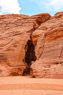
After a short drive up the canyon wash, you will reach this noticeable crack in the rock which is the entrance of Antilope Canyon.The pictures you will see below are looking upwards from inside the canyon. You will see the amazing colours generated by the rays of light piercing through the canyon dust. When looking at the last picture, taken close to 14h00, you can see the light is starting to get dimmer due to the sunshine no longer being vertical over the canyon
If all goes well, you will have completed the Antelope Canyon visit by 14h30 or 15h00 and should be ready to drive 10 minutes west from Page to stop on Route 89 at Horseshoe Bend parking. Once your car is stopped, you will have a short 10 minutes walk, first going uphill to reach a ridge and then slightly descending with a wide open view on a big crash in the ground :
This crash is the very beginning of the Grand Canyon and the Colorado river does a 180° bend which gave it the name of HorseShoe Bend :When driving back towards page on Route 89, should you have a bit of time left, you can continue on route 89 instead of turning right towards Page and can have 2 quick stops :
- The first one is on Scenic View Road from which a little road west brings to a circular car park. From there, you can walk down the canyon and have nice view on the Colorado River in addition to Glen Canyon Dam which retains all the water of Lake Powell
- The next place worth stopping is just after the road crosses Glen Canyon Damn where you can see the amazing architecture of the bridge and dam, in addition to geologic information on the dinosaurs that used to walk around this area millions of years ago
For the evening stay, my favorite place is slightly North of Page, overlooking Lake Power. Is it the Lake Powell Resort for which you must also integrate a cost to enter the Glen Dam National Recreation Area. However, you will be stunned by the sunrise on Lake Powell in the early morning and the direct view from the hotel onto the lake:
Day #4: From Page (AZ) to Bryce Canyon
Main milestones :
Page to Bryce : 2 hours 45 minutes
The route from Page to Bryce Canyon is very simple : it is along Route 89 for almost all the way, with 2 right turns onto Route 12 and Route 63 to Bryce Canyon City. There is however a fantastic alternative for people with a high clearance vehicle and only after several days of dry weather without rain : sightly after Big Water, you will find a track on the right named Cottonwood Canyon Road. This track is almost a direct route to Tropic which is slightly east and at a lower altitude than Bryce Canyon. Be aware that this track has a clay base, meaning if you take it, you must be sure of the weather forecast as you may stay stuck in the mud and mobile coverage is very rare.
Whatever road you take, there is a stop to do on the way if you have a bit of time. It is a small geologic curiosity known as Toadstools (a small scale variety of Hoodoos). the parking is on Highway 89 from Page to Kanab and the parking position is located HERE, approximatively 10 miles west from Big Water.
Whatever road you take, there is a stop to do on the way if you have a bit of time. It is a small geologic curiosity known as Toadstools (a small scale variety of Hoodoos). the parking is on Highway 89 from Page to Kanab and the parking position is located HERE, approximatively 10 miles west from Big Water.
Hoodoo / Toadstool
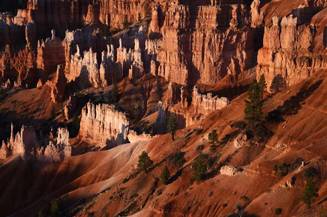
Back to our route, should you take the normal road and not Cottonwood Canyon, it is very pleasant and slowly takes you to the formations of Bryce Canyon, starting with Red Canyon, a small national park with amazing red rock formations. The road will drive right across Red Canyon and even goes beneath natural bridges until is reaches the plateau of Bryce Canyon. Bryce is even more amazing if you take a hike down in the canyon, in the middle of the hundreds of hoodoos. On the map below, Navajo Loop trail is a short hike but one of the most popular, just like Queen's Garden Trail and can be completed in less than 2 hours.
However, once finished, don't miss the opportunity to take your car right up the canyon to the further points such Bryce Point, and right at the end of the road, at a higher altitide where you regularly get snow, Rainbow Point.
Day #5: from Bryce Canyon to Las Vegas via Zion
This last day in the National Parks is maybe the less impressive but still takes you through a beautiful Park known as Zion. Please be aware there is a fare to enter the park, even if you are doing a quick drive through like we will. Details and precise costs can be found on Zion National Park Visitor Center web site. Should you want to skip this part, there is a shorter road higher North going through Cedar City.
Zion is very different from the other parks seen during the previous days. Indeed, the scenery changes from red sandstone to a mixed set of coloured rocks, with a different aspect from the others (no longer looks likes formations of clay & dust but solid rock with large smooth inclined surfaces).


